

REXUS has developed a Climate Risk Assessment for all five REXUS pilots, aiming to provide a comprehensive analysis on future climate risks focusing on hazard, vulnerability, and exposure indicators, including an assessment of their capacity to adapt to climate challenges. Dimitris Tassopoulos and Christina Papadaskalopoulou from Draxis, explain how the WEFE Nexus perspective was integrated in this assessment and present the advantages of this Nexus-informed assessment for decision-making over traditional approaches which examine sectors individually. Interviewed by GWP-Med.
Q. Please describe in a nutshell what the research aims to do?
This assessment aims to equip REXUS pilot areas with critical tools: detailed climate risk maps (climate risk results from the interaction of hazard, exposure and vulnerability) and maps of climate hazard indicators. It aims to quantify Water-Energy-Food Nexus-related climate risks and sheds light on the components that contribute to these risks across different sectors and regions, to enable better decision making.
The Climate Risk Assessment boosts more robust and adaptive strategies for managing climate risks.
Q. What is innovative in your approach?
The innovative aspect of this research is the integration of the Nexus perspective, which considers the interdependencies and interactions between the water, energy, and food sectors. It differs from traditional methods which typically assess climate risks in isolation. Our research incorporates cross-sectoral impacts, providing a more holistic understanding of climate risks.
Q. How does adding the Nexus perspective produce superior results?
The Nexus perspective offers several advantages:
1. Integrated Risk Assessment: The Nexus approach provides a comprehensive assessment of risks that may span multiple sectors, and may, for example, have mutually reinforcing effects between sectors.
2. Resource Efficiency: This approach helps identify opportunities for optimizing resource use anywhere across the WEFE Nexus spectrum, helping improve the overall efficiency of Water-Energy-Food systems.
3. Policy Coherence: It supports the development of coherent policies across various sectors, fostering more sustainable and resilient planning.
4. Stakeholder Collaboration: It encourages collaboration among stakeholders from different sectors, uniting them to address complex climate risks that concern all.
Overall, this holistic assessment allows for a better understanding of how climate change can impact the entire system rather than just its individual components, leading to more robust and adaptive strategies for managing climate risks.
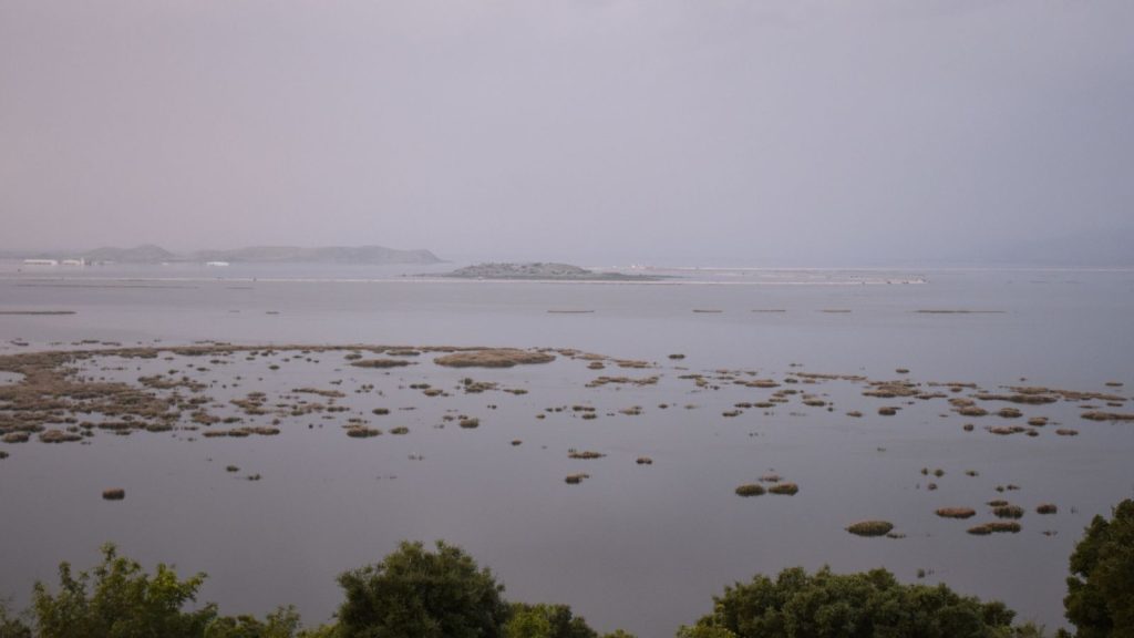
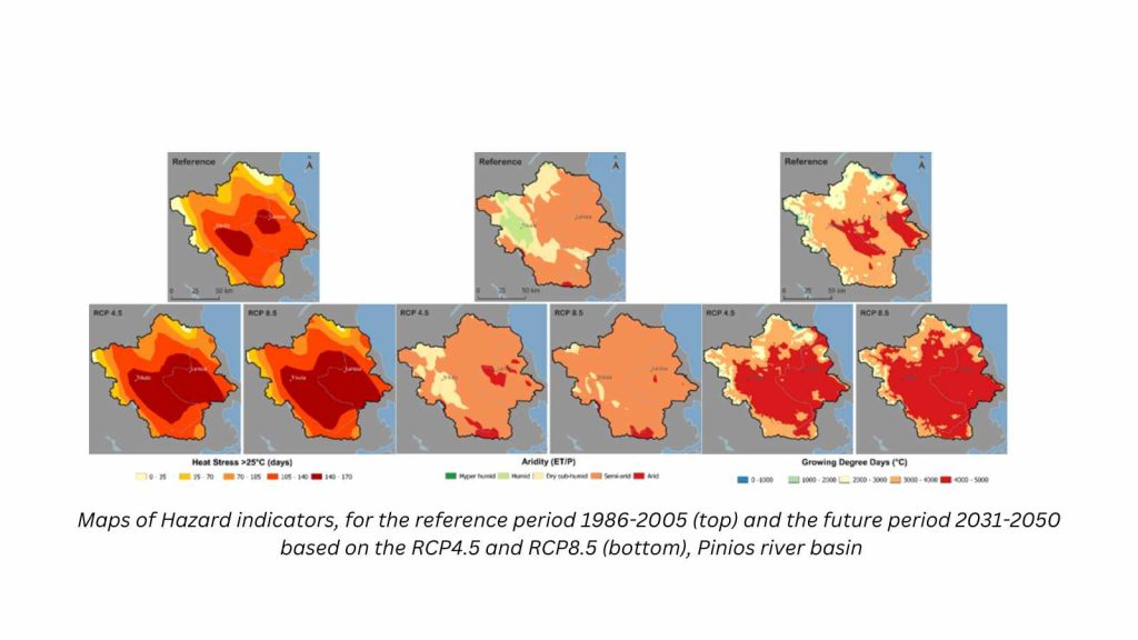
After Storm Daniel in September 2023, Lake Carla sited at the North Eastern end of the Pinios River basin, was flooded nearly tripling in size.
Q. What difficulties, obstacles, did you encounter?
In order to include all the different interactions and trade-offs between the various sectors, we had to incorporate several climate-related indicators. However, this was not an easy path to follow, because climate projections carry inherent uncertainty. To deal with this, we had to apply a validation method to evaluate the climate models’ performance for each pilot separately. Model outputs for the historical period were compared to the ERA5 reanalysis data for each parameter and pilot. The best-performing models were combined into an ensemble. Through this ensemble approach we managed to enhance the reliability of climate projections, by utilizing the strengths of multiple models and mitigating individual model biases or uncertainties.
Q. How can these results be useful to stakeholders and/or policymakers?
This assessment is useful in many ways for stakeholders and policymakers:
Comprehensive Data Integration: Traditional climate risk assessments often focus on isolated aspects such as hazard or exposure for one sector. In contrast, the Nexus approach integrates multiple indicators across hazards, vulnerabilities, and exposures, providing a holistic view. This helps policymakers understand the interconnected impacts of climate change and thus make more informed decisions. For example, using fewer indicators may lead us to conclude that, based on the expected increase in drought in a particular region, food production will be affected and therefore crops should be shifted to more drought-resistant ones. By including more indicators in the analysis, the NEXUS approach may ‘reveal’ also other risks, such as flood risk, and therefore, in areas identified as particularly vulnerable to flooding and also important for agriculture, investments can be directed towards improving drainage and flood barriers.
Prioritization of High-Risk Areas: By identifying areas with the highest combined risks, policymakers can prioritize resource allocation to regions most in need, optimizing the impact of climate adaptation measures.
Adaptive Capacity Consideration: Although not the primary focus of this analysis, the inclusion of adaptive capacity in the Climate Risk Assessment helps identify sectors where interventions can be most effective in reducing vulnerability.
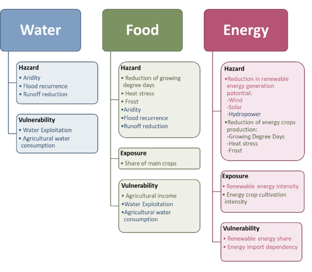
Figure 1. Climate risk indicators per WEF system, the Nexus WEF interconnections are represented with different colours related to each system.
Some examples relating to decision making:
Drought Resilience Programs: For the agricultural sector, the integrated risk assessment can inform the development of drought-resistant crop varieties and water-efficient irrigation practices. Policymakers can create incentives for farmers to adopt these practices, ensuring food security despite changing climatic conditions. Here, the Nexus approach is crucial in ensuring that we avoid maladaptation, by considering all key factors. For example, if we look only at the food sector, we will focus on areas of high exposure, ie those most heavily cultivated. However, climate change is expected to shift temperatures favorable for cultivation to areas that were not previously cultivated. Therefore, we also need to consider the water availability and water-related risks in those new areas and have a more complete understanding of future conditions there, in order to make informed decisions.
The findings from the Climate Risk Assessments can also be incorporated into policy documents. Municipalities can use the insights from the assessment to develop localized climate action plans that address specific risks unique to their regions.
Farmers and water managers can use the results to adjust agricultural practices and water usage. For example, areas projected to experience increased aridity might shift to more drought-resistant crops and implement advanced irrigation techniques to conserve water. These practices could be supported through agricultural extension services and water management policies, which could be updated to reflect the changing climate risks identified in our report.
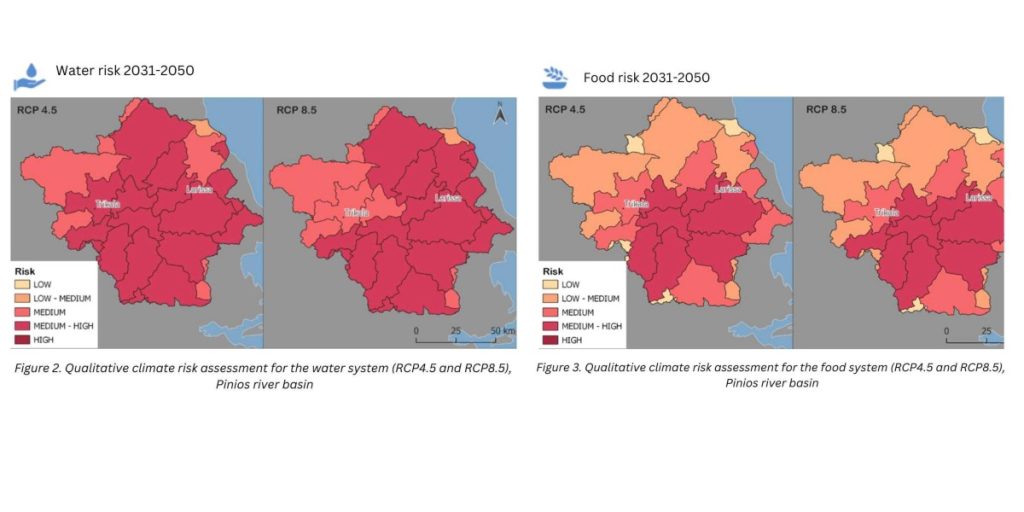
For example, our report concludes that the Isonzo-Soča region is expected to experience an increase in drought conditions, and identifies the areas most exposed. This could support regional plans to convert irrigation practices to drip irrigation systems with a more integrated approach, providing information on the most vulnerable areas.
Q. Did you identify any barriers to the adoption of the results of your research?
Some practical barriers in moving ‘from science to policymaking’ were highlighted during the assessment of the capacity of these pilot regions to adapt to climate change:
1. High Fragmentation of Responsibilities: The assessment highlighted a significant fragmentation of responsibilities among stakeholders involved in climate adaptation. For instance, in certain areas, 78% of respondents noted this fragmentation, which can hinder cohesive and effective climate adaptation strategies.
2. Limited Stakeholder Involvement: Despite the critical need for inclusive decision-making processes, the extent to which stakeholders are involved in assessing the impact of climate change and policy-making was found to be limited. In some cases, 63% to 78% of respondents indicated that stakeholder involvement was only moderate or limited.
3. Inadequate Funding: Funding for climate adaptation projects was predominantly rated as limited. This was surprising given the growing awareness and urgency of climate change impacts. For instance, 67% of respondents from certain regions rated the availability of funding as limited, with no respondents indicating high availability.
Q. What did the pilot stakeholders think of this analysis?
Stakeholders appreciated the detailed climate risk assessments, which highlighted critical areas for intervention. They expressed their intention to use these results to prioritize actions in areas identified as ‘high-risk’. In addition, stakeholders’ local knowledge of their sector was reasonably well aligned with the scientific results, which reinforced the relevance and applicability of the findings in local contexts. The findings also underscored the necessity of cross-border cooperation, as climate risks do not adhere to political boundaries. Stakeholders from different countries involved showed a strong interest in using the results to foster regional cooperation. They also valued the visual presentation of data (e.g., maps) which made complex information more accessible and actionable.
Q. What further research do you think could advance on these findings?
Future research could expand the Nexus-based assessment framework to more regions and sectors. This would provide a broader understanding of interdependencies and vulnerabilities, allowing for more robust and scalable adaptation strategies.
Read the Climate Risk Assessment here